
Gracias por apoyar a este sitio ❤️
Haz una donación
Haz una donación
Mapa topográfico Craichie
Haga clic en el mapa para ver la altitud.
Gracias por apoyar a este sitio ❤️
Haz una donación
Haz una donación
Acerca de este mapa
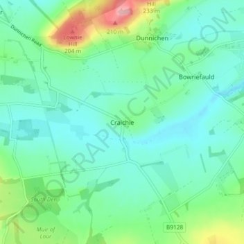
Nombre: Mapa topográfico Craichie, altitud, relieve.
Lugar: Craichie, Angus, Scotland, DD8 2LU, United Kingdom (56.59463 -2.83123 56.63463 -2.79123)
Altitud media: 121 m
Altitud mínima: 89 m
Altitud máxima: 225 m
Gracias por apoyar a este sitio ❤️
Haz una donación
Haz una donación
Otros mapas topográficos
Haga clic en un mapa para ver su topografía, su altitud y su relieve.
Gracias por apoyar a este sitio ❤️
Haz una donación
Haz una donación
Gracias por apoyar a este sitio ❤️
Haz una donación
Haz una donación
Gracias por apoyar a este sitio ❤️
Haz una donación
Haz una donación
Gracias por apoyar a este sitio ❤️
Haz una donación
Haz una donación