
Mapa topográfico Ilmenau
Mapa interactivo
Haga clic en el mapa para ver la altitud.
Acerca de este mapa
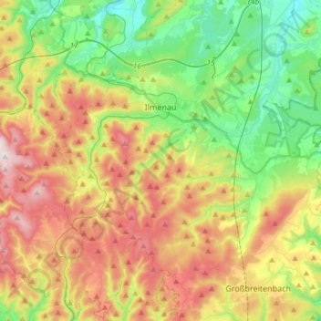
Nombre: Mapa topográfico Ilmenau, altitud, relieve.
Lugar: Ilmenau, Ilm-Kreis, Thuringia, Germany (50.56143 10.81823 50.74946 11.06661)
Altitud media: 604 m
Altitud mínima: 364 m
Altitud máxima: 965 m
Ilmenau (German pronunciation: [ˈɪlmənaʊ̯] (listen)) is a town in Thuringia, central Germany. It is the largest town within the Ilm district with a population of 38,600, while the district capital is Arnstadt. Ilmenau is located approximately 33 km (21 miles) south of Erfurt and 135 km (84 miles) north of Nuremberg within the Ilm valley at the northern edge of the Thuringian Forest at an elevation of 500 metres (1,640 feet).
Otros mapas topográficos
Haga clic en un mapa para ver su topografía, su altitud y su relieve.
Großbreitenbach
Germany > Thuringia > Ilm-Kreis > Großbreitenbach
Großbreitenbach, Ilm-Kreis, Thuringia, Germany
Altitud media: 596 m
Burg Ehrenstein
Germany > Thuringia > Ilm-Kreis > Stadtilm > Ehrenstein
Burg Ehrenstein, Ehrenstein, Stadtilm, Ilm-Kreis, Thuringia, 99326, Germany
Altitud media: 415 m