
Mapa topográfico Cambourne
Mapa interactivo
Haga clic en el mapa para ver la altitud.
Acerca de este mapa
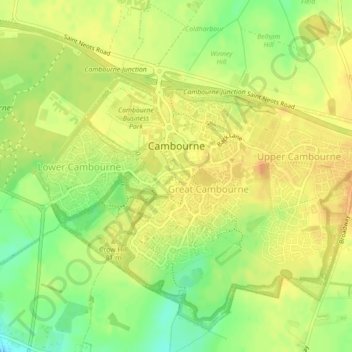
Nombre: Mapa topográfico Cambourne, altitud, relieve.
Altitud media: 65 m
Altitud mínima: 45 m
Altitud máxima: 76 m
Otros mapas topográficos
Haga clic en un mapa para ver su topografía, su altitud y su relieve.
Lake Ewart
United Kingdom > England > Cambourne
Lake Ewart, Crow Dene Bridleway, Cambourne, Cambridgeshire, East of England, England, CB23 5EP, United Kingdom
Altitud media: 63 m