
Mapa topográfico Romford
Mapa interactivo
Haga clic en el mapa para ver la altitud.
Acerca de este mapa
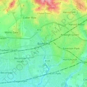
Nombre: Mapa topográfico Romford, altitud, relieve.
Lugar: Romford, Greater London, England, RM1 1RX, United Kingdom (51.53605 0.14226 51.61605 0.22226)
Altitud media: 29 m
Altitud mínima: 1 m
Altitud máxima: 109 m
The town centre is about 50 feet (15 m) above sea level on a gravel terrace rising from the River Thames. The north of the town has developed on London Clay and is situated as much as 150 ft (46 m) above sea level. A continuous gentle rise in the eastern suburbs towards Gidea Park and Harold Wood peaks around 177 feet (54 m) around the Harold Court. On the northern side, Harold Hill peaks at 75 m (246 ft). The semi-rural area north of Collier Row and Harold Hill consists of many rolls of hills, with elevation peaking at the village of Havering-atte-Bower, 344 feet (105 m). The town centre is for the most part contained within a ring road formed of St Edwards Way, Mercury Gardens, Thurloe Gardens, Oldchurch Road and Waterloo Road. The market place and much of South Street and the High Street are pedestrianised. The railway cuts through the town from east to west on a viaduct, with the bulk of the central Romford area to its north. The River Rom flows through the town in underground channels and joins the Thames after flowing through Hornchurch; elsewhere along its course it is known as the River Beam and forms part of the strategic waterways Blue Ribbon Network. Romford has formed part of the continuously built-up area of London since the 1930s and is contiguous with Rush Green to the west, Collier Row to the north, Gidea Park to the east and Hornchurch to the south east.
Otros mapas topográficos
Haga clic en un mapa para ver su topografía, su altitud y su relieve.
London
United Kingdom > England > London
London, Greater London, England, SW1A 2DX, United Kingdom
Altitud media: 42 m
Bristol
United Kingdom > England > City of Bristol
Bristol, City of Bristol, West of England, England, United Kingdom
Altitud media: 55 m
St Albans
United Kingdom > England > Hertfordshire > St Albans
St Albans, Hertfordshire, East of England, England, United Kingdom
Altitud media: 100 m
Liverpool
Liverpool, Liverpool City Region, England, United Kingdom
Altitud media: 26 m
Birmingham
Birmingham, West Midlands Combined Authority, England, United Kingdom
Altitud media: 138 m
Sheffield
Sheffield, South Yorkshire, England, United Kingdom
Altitud media: 168 m
Nottingham
United Kingdom > England > Nottinghamshire
Nottingham, England, United Kingdom
Altitud media: 56 m
Lincolnshire
Lincolnshire, East Midlands, England, United Kingdom
Altitud media: 28 m
Oxford
United Kingdom > England > Oxfordshire
Oxford, Oxfordshire, England, United Kingdom
Altitud media: 81 m
Coventry
Coventry, West Midlands Combined Authority, England, United Kingdom
Altitud media: 99 m
South East England
South East England, England, United Kingdom
Altitud media: 69 m
Somerset
Somerset, South West England, England, United Kingdom
Altitud media: 87 m
Greater Manchester
Greater Manchester, England, United Kingdom
Altitud media: 141 m
Leighton Buzzard
United Kingdom > England > Central Bedfordshire
Leighton Buzzard, Central Bedfordshire, England, LU7 1EE, United Kingdom
Altitud media: 103 m
Sutton Coldfield
United Kingdom > England > Birmingham
Sutton Coldfield, Birmingham, West Midlands Combined Authority, England, United Kingdom
Altitud media: 124 m
Cambridge
United Kingdom > England > Cambridge
Cambridge, Cambridgeshire, East of England, England, United Kingdom
Altitud media: 18 m
Hull
United Kingdom > England > Kingston upon Hull
Hull, Kingston upon Hull, England, HU1 3RJ, United Kingdom
Altitud media: 21 m
Leasowe Lighthouse
United Kingdom > England > Moreton
Leasowe Lighthouse, Lingham Lane, Moreton, Wirral, Liverpool City Region, England, CH46 4TB, United Kingdom
Altitud media: 4 m
Lancaster
United Kingdom > England > Lancashire
Lancaster, Lancashire, England, United Kingdom
Altitud media: 84 m
Leeds
United Kingdom > England > Leeds
Leeds, Yorkshire and the Humber, England, LS1 6AL, United Kingdom
Altitud media: 94 m
Wimbledon
Wimbledon, Greater London, England, SW19 7NL, United Kingdom
Altitud media: 26 m
Wirral
Wirral, Liverpool City Region, England, United Kingdom
Altitud media: 21 m
City of London
United Kingdom > England > City of London > City of London
City of London, England, EC2V 5AE, United Kingdom
Altitud media: 42 m
Macclesfield
United Kingdom > England > Macclesfield
Macclesfield, Cheshire East, North West England, England, SK10 1EA, United Kingdom
Altitud media: 189 m
Maidenhead
United Kingdom > England > Royal Borough of Windsor and Maidenhead
Maidenhead, Royal Borough of Windsor and Maidenhead, England, SL6 1QB, United Kingdom
Altitud media: 41 m
Newcastle upon Tyne
Newcastle upon Tyne, North of Tyne, England, United Kingdom
Altitud media: 57 m
Llanrothal
United Kingdom > England > Herefordshire
Llanrothal, Herefordshire, England, United Kingdom
Altitud media: 101 m
Knayton
United Kingdom > England > North Yorkshire
Knayton, North Yorkshire, England, YO7 4AY, United Kingdom
Altitud media: 76 m
Bagby
United Kingdom > England > North Yorkshire
Bagby, North Yorkshire, England, United Kingdom
Altitud media: 48 m
North West England
North West England, England, United Kingdom
Altitud media: 118 m
East Riding of Yorkshire
East Riding of Yorkshire, England, United Kingdom
Altitud media: 30 m
Scunthorpe
United Kingdom > England > North Lincolnshire
Scunthorpe, North Lincolnshire, England, DN15 6SD, United Kingdom
Altitud media: 28 m
Harrogate
United Kingdom > England > North Yorkshire
Harrogate, North Yorkshire, England, United Kingdom
Altitud media: 131 m
Stroud
United Kingdom > England > Gloucestershire
Stroud, Gloucestershire, England, United Kingdom
Altitud media: 113 m
Carlisle
United Kingdom > England > Cumberland
Carlisle, Cumberland, England, United Kingdom
Altitud media: 31 m