
Mapa topográfico Daventry
Mapa interactivo
Haga clic en el mapa para ver la altitud.
Acerca de este mapa
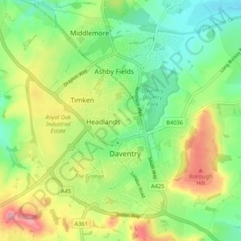
Nombre: Mapa topográfico Daventry, altitud, relieve.
Lugar: Daventry, West Northamptonshire, England, United Kingdom (52.24172 -1.19940 52.28750 -1.12449)
Altitud media: 148 m
Altitud mínima: 102 m
Altitud máxima: 220 m
According to local folklore Daventry had Danish (Viking) origins, this was partly due to the old pronunciation of Daventry as Daintry, which was interpreted as "Dane Tree", however in more modern interpretation the town's name is thought likelier to be Anglo-Saxon in origin: "Dafa's tree" (Dafa being a founding father or paterfamila) and there was very likely a meeting tree, possibly on Borough Hill. Thus the name may have been formed on lines similar to Coventry ("Cofa's tree", i.e. "tree of Cofa"). Another theory which was popular in the 19th century, was that of Thomas Pennant, the Welsh naturalist and antiquarian, who acknowledged the town's 'considerable antiquity' and speculated that the name was Brythonic, dwy-avon-tre (town of two rivers), a derivation seemingly supported by the town's topography, situated as it is between the sources of the River Leam, which flows west, and the River Nene which flows east. This theory however is now discredited.
Otros mapas topográficos
Haga clic en un mapa para ver su topografía, su altitud y su relieve.
Northampton
United Kingdom > England > West Northamptonshire > Northampton
Northampton, West Northamptonshire, England, United Kingdom
Altitud media: 89 m
Long Buckby Wharf
United Kingdom > England > West Northamptonshire
Long Buckby Wharf, Long Buckby, West Northamptonshire, England, NN6 7PP, United Kingdom
Altitud media: 114 m
Fosters Booth
United Kingdom > England > West Northamptonshire
Fosters Booth, Pattishall, West Northamptonshire, England, NN12 8LB, United Kingdom
Altitud media: 128 m
Northampton
United Kingdom > England > West Northamptonshire
Northampton, West Northamptonshire, England, United Kingdom
Altitud media: 89 m
Yardley Hastings
United Kingdom > England > West Northamptonshire
Yardley Hastings, West Northamptonshire, England, United Kingdom
Altitud media: 94 m
Spratton
United Kingdom > England > West Northamptonshire
Spratton, West Northamptonshire, England, United Kingdom
Altitud media: 98 m
Litchborough
United Kingdom > England > West Northamptonshire
Litchborough, West Northamptonshire, England, United Kingdom
Altitud media: 142 m
Upton Country Park
United Kingdom > England > West Northamptonshire > Harpole
Upton Country Park, Upton, Harpole, West Northamptonshire, England, United Kingdom
Altitud media: 75 m
Castle Ashby
United Kingdom > England > West Northamptonshire
Castle Ashby, West Northamptonshire, England, NN7 1LF, United Kingdom
Altitud media: 71 m
Lower Thorpe
United Kingdom > England > West Northamptonshire > Thorpe Mandeville
Lower Thorpe, Thorpe Mandeville, West Northamptonshire, England, OX17 2HP, United Kingdom
Altitud media: 154 m
Maidford
United Kingdom > England > West Northamptonshire
Maidford, West Northamptonshire, England, United Kingdom
Altitud media: 157 m
Onley
United Kingdom > England > West Northamptonshire
Onley, West Northamptonshire, England, CV23 8AW, United Kingdom
Altitud media: 99 m
Stoke Bruerne
United Kingdom > England > West Northamptonshire
Stoke Bruerne, West Northamptonshire, England, NN12 7SD, United Kingdom
Altitud media: 98 m
Great Brington
United Kingdom > England > West Northamptonshire
Great Brington, West Northamptonshire, England, NN7 4JD, United Kingdom
Altitud media: 118 m
Nether Heyford
United Kingdom > England > West Northamptonshire
Nether Heyford, West Northamptonshire, England, United Kingdom
Altitud media: 91 m
Foxley
United Kingdom > England > West Northamptonshire > Blakesley
Foxley, Blakesley, West Northamptonshire, England, NN12 8HP, United Kingdom
Altitud media: 139 m
Sibbertoft
United Kingdom > England > West Northamptonshire > Sibbertoft
Sibbertoft, West Northamptonshire, England, United Kingdom
Altitud media: 156 m
Thenford
United Kingdom > England > West Northamptonshire
Thenford, West Northamptonshire, England, United Kingdom
Altitud media: 134 m
Braunston
United Kingdom > England > West Northamptonshire > Braunston
Braunston, West Northamptonshire, England, United Kingdom
Altitud media: 128 m
Blakesley
United Kingdom > England > West Northamptonshire
Blakesley, West Northamptonshire, England, United Kingdom
Altitud media: 141 m
Creaton
United Kingdom > England > West Northamptonshire > Great Creaton
Creaton, Great Creaton, West Northamptonshire, England, United Kingdom
Altitud media: 106 m
Draughton
United Kingdom > England > West Northamptonshire
Draughton, West Northamptonshire, England, United Kingdom
Altitud media: 140 m
Watford Gap
United Kingdom > England > West Northamptonshire
Watford Gap, Watford, West Northamptonshire, England, NN6 7UH, United Kingdom
Altitud media: 139 m
Tiffield
United Kingdom > England > West Northamptonshire
Tiffield, West Northamptonshire, England, NN12 8AB, United Kingdom
Altitud media: 122 m
Brockhall
United Kingdom > England > West Northamptonshire
Brockhall, West Northamptonshire, England, United Kingdom
Altitud media: 105 m
Silverstone
United Kingdom > England > West Northamptonshire
Silverstone, West Northamptonshire, England, United Kingdom
Altitud media: 133 m
Kelmarsh
United Kingdom > England > West Northamptonshire
Kelmarsh, West Northamptonshire, England, United Kingdom
Altitud media: 138 m
Hunsbury Hill
United Kingdom > England > West Northamptonshire > Far Cotton
Hunsbury Hill, Far Cotton, West Northamptonshire, England, NN4 9RR, United Kingdom
Altitud media: 79 m
Harlestone
United Kingdom > England > West Northamptonshire
Harlestone, West Northamptonshire, England, United Kingdom
Altitud media: 102 m
Barby
United Kingdom > England > West Northamptonshire
Barby, West Northamptonshire, England, United Kingdom
Altitud media: 114 m
Croughton
United Kingdom > England > West Northamptonshire
Croughton, West Northamptonshire, England, United Kingdom
Altitud media: 127 m
Old Mill Race
United Kingdom > England > West Northamptonshire > Whilton
Old Mill Race, Norton, Whilton, West Northamptonshire, England, NN7 4JZ, United Kingdom
Altitud media: 109 m
Pattishall
United Kingdom > England > West Northamptonshire
Pattishall, West Northamptonshire, England, United Kingdom
Altitud media: 125 m
Ladybridge Park
United Kingdom > England > West Northamptonshire
Ladybridge Park, West Hunsbury, West Northamptonshire, England, United Kingdom
Altitud media: 81 m
Bradden
United Kingdom > England > West Northamptonshire
Bradden, West Northamptonshire, England, United Kingdom
Altitud media: 118 m
Whitfield
United Kingdom > England > West Northamptonshire
Whitfield, West Northamptonshire, England, United Kingdom
Altitud media: 128 m
Duston
United Kingdom > England > West Northamptonshire > Duston
Duston, West Northamptonshire, England, United Kingdom
Altitud media: 97 m
Puxley
United Kingdom > England > West Northamptonshire
Puxley, Deanshanger, West Northamptonshire, England, NN12 7QS, United Kingdom
Altitud media: 95 m
Sulgrave
United Kingdom > England > West Northamptonshire
Sulgrave, West Northamptonshire, England, United Kingdom
Altitud media: 157 m
Honey Hill
United Kingdom > England > West Northamptonshire
Honey Hill, West Northamptonshire, England, NN6 6NL, United Kingdom
Altitud media: 169 m
Edgcote
United Kingdom > England > West Northamptonshire > Chipping Warden
Edgcote, Chipping Warden and Edgcote, Chipping Warden, West Northamptonshire, England, OX17 1AG, United Kingdom
Altitud media: 133 m
Preston Capes
United Kingdom > England > West Northamptonshire
Preston Capes, West Northamptonshire, England, United Kingdom
Altitud media: 156 m
Middleton Cheney
United Kingdom > England > West Northamptonshire
Middleton Cheney, West Northamptonshire, England, United Kingdom
Altitud media: 128 m
Moreton Pinkney
United Kingdom > England > West Northamptonshire
Moreton Pinkney, West Northamptonshire, England, United Kingdom
Altitud media: 151 m
Overstone
United Kingdom > England > West Northamptonshire
Overstone, West Northamptonshire, England, United Kingdom
Altitud media: 109 m
Upper Stowe
United Kingdom > England > West Northamptonshire > Upper Stowe
Upper Stowe, West Northamptonshire, England, NN7 4SL, United Kingdom
Altitud media: 115 m
Kingsthorpe
United Kingdom > England > West Northamptonshire
Kingsthorpe, West Northamptonshire, England, United Kingdom
Altitud media: 95 m
East Hunsbury
United Kingdom > England > West Northamptonshire
East Hunsbury, West Northamptonshire, England, United Kingdom
Altitud media: 87 m
Hellidon
United Kingdom > England > West Northamptonshire
Hellidon, West Northamptonshire, England, United Kingdom
Altitud media: 159 m
Great Oxendon
United Kingdom > England > West Northamptonshire
Great Oxendon, West Northamptonshire, England, United Kingdom
Altitud media: 123 m