
Mapa topográfico Cambridge
Mapa interactivo
Haga clic en el mapa para ver la altitud.
Acerca de este mapa
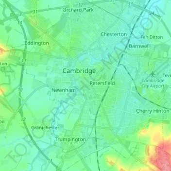
Nombre: Mapa topográfico Cambridge, altitud, relieve.
Altitud media: 18 m
Altitud mínima: 2 m
Altitud máxima: 79 m
The city, like most of the UK, has a maritime climate highly influenced by the Gulf Stream. Located in the driest region of Britain, Cambridge's rainfall averages around 570 mm (22.44 in) per year, around half the national average, with some years occasionally falling into the semi-arid (under 500 mm (19.69 in) of rain per year) category. The last time this occurred was in 2011 with 380.4 mm (14.98 in) of rain at the Botanic Garden and 347.2 mm (13.67 in) at the NIAB site. Conversely, 2012 was the wettest year on record, with 812.7 mm (32.00 in) reported. Snowfall accumulations are usually small, in part because of Cambridge's low elevation, and low precipitation tendency during transitional snow events.
Otros mapas topográficos
Haga clic en un mapa para ver su topografía, su altitud y su relieve.
West Pit
United Kingdom > England > Cambridge
West Pit, Lime Kiln Road, Cherry Hinton, Cambridge, Cambridgeshire, East of England, England, CB1 9NH, United Kingdom
Altitud media: 26 m
Mansfield Court
United Kingdom > England > Cambridge
Mansfield Court, Cambridge, Cambridgeshire, East of England, England, CB4 1ES, United Kingdom
Altitud media: 12 m
Quy Water
United Kingdom > England > Cambridge
Quy Water, Cambridge, Cambridgeshire, East of England, England, CB1 9BG, United Kingdom
Altitud media: 13 m