
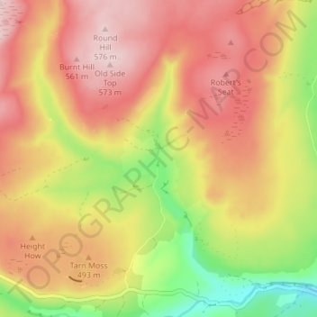
Mapa topográfico Ravenseat
Mapa interactivo
Haga clic en el mapa para ver la altitud.
Acerca de este mapa
Nombre: Mapa topográfico Ravenseat, altitud, relieve.
Altitud media: 468 m
Altitud mínima: 323 m
Altitud máxima: 574 m
Otros mapas topográficos
Haga clic en un mapa para ver su topografía, su altitud y su relieve.
Scarborough
United Kingdom > England > North Yorkshire
The climate is temperate with mild summers and cool, windy, winters. The hottest months of the year are July and August, with temperatures reaching an average high of 17 °C and falling to 11 °C at night. The average daytime temperatures in January are 4 °C, falling to 1 °C at night. The station's elevation…
Altitud media: 50 m
Harrogate
United Kingdom > England > North Yorkshire
Harrogate is situated on the edge of the Yorkshire Dales, with the Vale of York to the east and the upland Yorkshire Dales to the west and north-west. It has a dry and mild climate, typical of places in the rain shadow of the Pennines. It is on the A59 from Skipton to York. At an altitude of between 100 and…
Altitud media: 131 m
Hawnby
United Kingdom > England > North Yorkshire
The village sits at the junction of several small roads at the head of two valleys, close to the B1257 road between Oswaldkirk and Stokesley. The nearest settlements are Boltby 3.7 miles (6 km) to the south-west; Old Byland 2.3 miles (3.7 km) to the south and Fangdale Beck 3.4 miles (5.5 km) to the north. It…
Altitud media: 258 m
North York Moors National Park
United Kingdom > England > North Yorkshire
As part of the United Kingdom, the North York Moors area generally has warm summers and relatively mild winters. Weather conditions vary from day to day as well as from season to season. The latitude of the area means that it is influenced by predominantly westerly winds with depressions and their associated…
Altitud media: 110 m
Hebden
United Kingdom > England > North Yorkshire
The name Hebden may be derived from either heope, Old English for a rose-hip or heopa, Old English for a bramble, and dene, Old English for a valley, or from the Scandinavian Hebban, a topographical description of a ridge forming an elevated site above a small valley. Two Bronze Age stone circles and remnants…
Altitud media: 329 m
River Derwent
United Kingdom > England > North Yorkshire
Rainfall and climate conditions vary slightly across the Derwent catchment area due to the topography. Annual rainfall ranges from averages of 600 millimetres (24 in) at Barmby Barrage to over 1,100 millimetres (43 in) at its source on the North York Moors.
Altitud media: 56 m
Crayke
United Kingdom > England > North Yorkshire
The name Crayke is of Brittonic origin, derived from the neo-Brittonic Cumbric crẹ:g, meaning "a crag" or "prominent rock" (Welsh craig). This derivation may refer to the topography associated with the Northumbrian monastery at Crayke.
Altitud media: 62 m
Hawnby
United Kingdom > England > North Yorkshire
The village sits at the junction of several small roads at the head of two valleys, close to the B1257 road between Oswaldkirk and Stokesley. The nearest settlements are Boltby 3.7 miles (6 km) to the south-west; Old Byland 2.3 miles (3.7 km) to the south and Fangdale Beck 3.4 miles (5.5 km) to the north. It…
Altitud media: 258 m
Thornton in Craven
United Kingdom > England > North Yorkshire > Thornton In Craven
Altitud media: 189 m