
Mapa topográfico Irvinestown
Mapa interactivo
Haga clic en el mapa para ver la altitud.
Acerca de este mapa
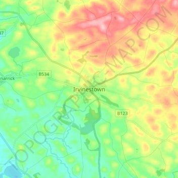
Nombre: Mapa topográfico Irvinestown, altitud, relieve.
Altitud media: 95 m
Altitud mínima: 41 m
Altitud máxima: 179 m
Otros mapas topográficos
Haga clic en un mapa para ver su topografía, su altitud y su relieve.
Brookeborough
United Kingdom > Northern Ireland > County Fermanagh
Brookeborough, County Fermanagh, Northern Ireland, BT94 4EZ, United Kingdom
Altitud media: 97 m
Brattan's Hill
United Kingdom > Northern Ireland > County Fermanagh
Brattan's Hill, Ardunshin, County Fermanagh, Northern Ireland, BT94 4RT, United Kingdom
Altitud media: 79 m
White Island
United Kingdom > Northern Ireland > County Fermanagh
White Island, County Fermanagh, Ulster, Northern Ireland, United Kingdom
Altitud media: 48 m
Lough Navar
United Kingdom > Northern Ireland > County Fermanagh
Lough Navar, Barr of Drumbadmeen, County Fermanagh, Ulster, Northern Ireland, United Kingdom
Altitud media: 232 m
Carr
United Kingdom > Northern Ireland > County Fermanagh
Carr, County Fermanagh, Northern Ireland, United Kingdom
Altitud media: 60 m
Ederney
United Kingdom > Northern Ireland > County Fermanagh
Ederney, County Fermanagh, Northern Ireland, BT93 0DG, United Kingdom
Altitud media: 91 m
Tempo
United Kingdom > Northern Ireland > County Fermanagh > Tempo
Tempo, County Fermanagh, Northern Ireland, BT94 3LU, United Kingdom
Altitud media: 127 m
Bellanaleck
United Kingdom > Northern Ireland > County Fermanagh
Bellanaleck, County Fermanagh, Ulster, Northern Ireland, BT92 2BA, United Kingdom
Altitud media: 54 m
Belcoo
United Kingdom > Northern Ireland > County Fermanagh
Belcoo, County Fermanagh, Ulster, Northern Ireland, BT93 5FB, United Kingdom
Altitud media: 86 m
Derrygonnelly
United Kingdom > Northern Ireland > County Fermanagh
Derrygonnelly, County Fermanagh, Ulster, Northern Ireland, BT93 6HW, United Kingdom
Altitud media: 79 m
Cuilcagh
United Kingdom > Northern Ireland > County Fermanagh
Cuilcagh, Cavan-Belturbet Municipal District, County Cavan, Ireland
Altitud media: 472 m