
Mapa topográfico Elkwater
Mapa interactivo
Haga clic en el mapa para ver la altitud.
Elkwater
The Elkwater townsite lies at an elevation of about 1,225 m (4,025 ft) on the northwest slope of the Cypress Hills which, with a summit at 1,466 m (4810 ft), are the highest point between the Rocky Mountains and Labrador within Canada. Because of the elevation, the area receives more moisture than the surrounding plains. Forests of lodgepole pine, white spruce, and aspen cover the north-facing slopes above the town. Large animals include mule deer, white-tailed deer, coyote, elk, cougar, and moose, and many types of birds. Moose and wild turkeys were introduced to the area and are not native. Furthermore, there is a large lake that has northern pike and yellow perch. Nearby lakes such as Reesor Lake also have fishing available. Sport fishing Licenses are available online or can be acquired from the Elkwater Visitor Centre.
Acerca de este mapa
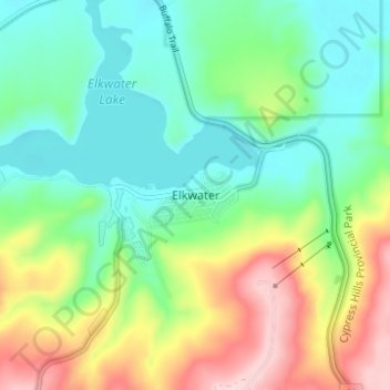
Nombre: Mapa topográfico Elkwater, altitud, relieve.
Lugar: Elkwater, Cypress County, Alberta, T0J 1C0, Canada (49.64137 -110.30235 49.68137 -110.26235)
Altitud media: 1.294 m
Altitud mínima: 1.217 m
Altitud máxima: 1.445 m
Otros mapas topográficos
Haga clic en un mapa para ver su topografía, su altitud y su relieve.