
Mapa topográfico Manicouagan
Mapa interactivo
Haga clic en el mapa para ver la altitud.
Acerca de este mapa
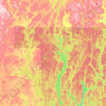
Nombre: Mapa topográfico Manicouagan, altitud, relieve.
Lugar: Manicouagan, Côte-Nord, Quebec, Canada (49.79567 -69.40767 51.07567 -68.12767)
Altitud media: 496 m
Altitud mínima: 112 m
Altitud máxima: 1.044 m
Otros mapas topográficos
Haga clic en un mapa para ver su topografía, su altitud y su relieve.
Quebec
Canada > Quebec > Urban agglomeration of Québec
Quebec City was built on the north bank of the Saint Lawrence River, where it narrows and meets the mouth of the Saint-Charles River. Old Quebec is located on top and at the foot of Cap-Diamant, which is on the eastern edge of a plateau called the promontory of Quebec (Quebec hill). Because of this topographic…
Altitud media: 117 m
Parc Herbert-Brown-Ames
Canada > Quebec > Urban agglomeration of Montreal > Montreal
Altitud media: 32 m