
Mapa topográfico Nusa Penida
Mapa interactivo
Haga clic en el mapa para ver la altitud.
Nusa Penida
La isla tiene una superficie de unos 203 km², con una longitud de unos 20 km y un ancho de 12 km. Al noroeste de Nusa Penida hay dos pequeñas islas, Nusa Lembongan y Nusa Ceningan. El estrecho de Badung la separa de Bali. El interior de la isla es montañoso con una altitud máxima de 524 metros. Es más seco que la isla cercana de Bali.
Acerca de este mapa
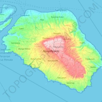
Nombre: Mapa topográfico Nusa Penida, altitud, relieve.
Lugar: Nusa Penida, Batukandik, Bali, Indonesia (-8.81953 115.44670 -8.67170 115.62855)
Altitud media: 104 m
Altitud mínima: -4 m
Altitud máxima: 517 m
Otros mapas topográficos
Haga clic en un mapa para ver su topografía, su altitud y su relieve.