
Mapa topográfico Quebec
Haga clic en el mapa para ver la altitud.
Quebec
La topografía de la ciudad constituye, por un extremo, la colina de Quebec, donde se encuentran los municipios de Sainte-Foy - Sillery - Cap-Rouge y La Cité-Limoilou (en parte), y por el otro extremo, la ladera de Beauport, que influyó fuertemente en la ocupación del territorio.
Acerca de este mapa
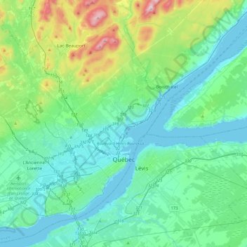
Nombre: Mapa topográfico Quebec, altitud, relieve.
Altitud media: 117 m
Altitud mínima: -3 m
Altitud máxima: 629 m