Mapa topográfico Toronto
Mapa interactivo
Haga clic en el mapa para ver la altitud.
Acerca de este mapa
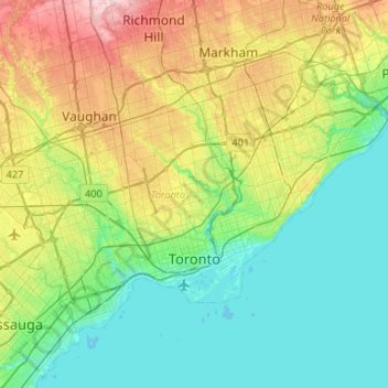
Nombre: Mapa topográfico Toronto, altitud, relieve.
Lugar: Toronto, Golden Horseshoe, Ontario, Canada (43.58025 -79.63927 43.85544 -79.11322)
Altitud media: 140 m
Altitud mínima: 69 m
Altitud máxima: 332 m
Despite its deep ravines, Toronto is not remarkably hilly, but its elevation does increase steadily away from the lake. Elevation differences range from 76.5 metres (251 ft) above sea level at the Lake Ontario shore to 209 m (686 ft) above sea level near the York University grounds in the city's north end at the intersection of Keele Street and Steeles Avenue. There are occasional hilly areas; in particular, midtown Toronto has a number of sharply sloping hills. Lake Ontario remains occasionally visible from the peaks of these ridges as far north as Eglinton Avenue, 7 to 8 kilometres (4.3 to 5.0 mi) inland.
Otros mapas topográficos
Haga clic en un mapa para ver su topografía, su altitud y su relieve.
Alexandra Park
Alexandra Park, Spadina—Fort York, Old Toronto, Toronto, Ontario, Canada
Altitud media: 98 m