
Mapa topográfico 城关区 ཁྲིན་ཀོན་ཆུས།
Mapa interactivo
Haga clic en el mapa para ver la altitud.
Acerca de este mapa
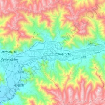
Nombre: Mapa topográfico 城关区 ཁྲིན་ཀོན་ཆུས།, altitud, relieve.
Lugar: 城关区 ཁྲིན་ཀོན་ཆུས།, Lhasa, Tibet, 850000, China (29.51215 91.01220 29.80326 91.30094)
Altitud media: 4.325 m
Altitud mínima: 3.614 m
Altitud máxima: 5.654 m
Otros mapas topográficos
Haga clic en un mapa para ver su topografía, su altitud y su relieve.
ཤིས་ས་སྤང་མ། 希夏邦马峰
China > Tibet > 聂拉木县 གཉའ་ལམ་རྫོང་ > Nyalam
El Shisha Pangma está ubicado en la zona centro-meridional del Tíbet, a tan sólo cinco kilómetros de la frontera con Nepal. De hecho, se trata del único ochomil que se encuentra situado íntegramente en territorio chino. Es también el pico más alto de la cordillera Jugal Himal, que se considera…
Altitud media: 7.222 m