
Mapa topográfico Sonoma County
Mapa interactivo
Haga clic en el mapa para ver la altitud.
Acerca de este mapa
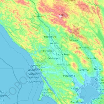
Nombre: Mapa topográfico Sonoma County, altitud, relieve.
Lugar: Sonoma County, California, Estados Unidos de América (38.06953 -123.63250 38.85265 -122.34970)
Altitud media: 210 m
Altitud mínima: -4 m
Altitud máxima: 1.426 m
Otros mapas topográficos
Haga clic en un mapa para ver su topografía, su altitud y su relieve.
Gordon E. Oliver Eden Shores Park
Estados Unidos de América > California > Condado de Alameda > Hayward
Altitud media: 1 m
Mira Loma
Estados Unidos de América > California > Riverside County > Jurupa Valley
Altitud media: 210 m
Lake Hollywood Park
Estados Unidos de América > California > Condado de Los Ángeles > Los Ángeles
Altitud media: 285 m
Fish Traps Archeological Site
Estados Unidos de América > California > Riverside County
Altitud media: 53 m
Corralitos
Estados Unidos de América > California > Santa Cruz County > Corralitos
Altitud media: 166 m
Colonia Juarez
Estados Unidos de América > California > Orange County > Fountain Valley
Altitud media: 12 m
Santa Clarita
Estados Unidos de América > California > Los Angeles County > Santa Clarita
Altitud media: 525 m
Casmalia
Estados Unidos de América > California > Santa Barbara County > Casmalia
Altitud media: 150 m