
Gracias por apoyar a este sitio ❤️
Haz una donación
Haz una donación
Mapa topográfico St. Albans
Haga clic en el mapa para ver la altitud.
Gracias por apoyar a este sitio ❤️
Haz una donación
Haz una donación
Acerca de este mapa
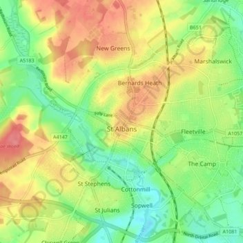
Nombre: Mapa topográfico St. Albans, altitud, relieve.
Lugar: St. Albans, St Albans, Hertfordshire, Inglaterra, Reino Unido (51.72913 -0.37529 51.78007 -0.29102)
Altitud media: 103 m
Altitud mínima: 69 m
Altitud máxima: 141 m
Gracias por apoyar a este sitio ❤️
Haz una donación
Haz una donación