
Mapa topográfico Pekín
Mapa interactivo
Haga clic en el mapa para ver la altitud.
Pekín
Pekín está situada en el extremo norte de la llanura del norte de China, aproximadamente triangular, que se abre al sur y al este de la ciudad. Las montañas al norte, noroeste y oeste protegen la ciudad y el corazón agrícola del norte de China de las invasoras estepas del desierto. La parte noroeste del municipio, especialmente el condado de Yanqing y el distrito de Huairou, están dominados por las montañas Jundu, mientras que la parte occidental está enmarcada por Xishan o las colinas occidentales. La Gran Muralla China, en la parte norte del municipio de Beijing, se construyó sobre la escarpada topografía para defenderse contra las incursiones nómadas de las estepas. El Monte Dongling, en las colinas occidentales y en la frontera con Hebei, es el punto más alto del municipio, con una altitud de 2303 metros.
Acerca de este mapa
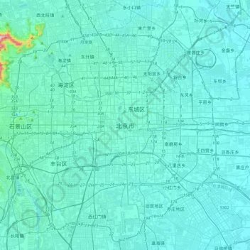
Nombre: Mapa topográfico Pekín, altitud, relieve.
Lugar: Pekín, Distrito de Dongcheng, Pekín, 100010, China (39.74571 116.23130 40.06571 116.55130)
Altitud media: 47 m
Altitud mínima: 18 m
Altitud máxima: 509 m