
Mapa topográfico Islamabad
Mapa interactivo
Haga clic en el mapa para ver la altitud.
Islamabad
Islamabad está localizada en las coordenadas 33°26′N 73°02′E / 33.43, 73.04, en el extremo norte de la meseta de Potohar, en el territorio Capital de Islamabad. Su altitud es de 540 metros. La capital moderna y la antigua ciudad de Rawalpindi están lado a lado y se conocen comúnmente como ciudades gemelas, no existe un límite exacto entre las dos ciudades. Al noroeste de la ciudad está la estación de montaña Murree, y al norte el distrito de Haripur en Jaiber Pajtunjuá. Kahuta se encuentra en el sureste, Taxila, Wah Cantt, y el distrito de Attock al noroeste, Gujar Khan, Rawat, y Mandrah al sureste, y la metrópolis de Rawalpindi al sur y suroeste. Islamabad está localizada a 120 km de Muzaffarabad, a 185 km de Peshawar, a 295 km de Lahore, y a 300 km de Srinagar, la capital de Jammu y Cachemira en la India.
Acerca de este mapa
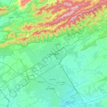
Nombre: Mapa topográfico Islamabad, altitud, relieve.
Lugar: Islamabad, زون 1, وفاقی دارالحکومت اسلام آباد, 44000, Pakistán (33.53381 72.90515 33.85381 73.22515)
Altitud media: 666 m
Altitud mínima: 417 m
Altitud máxima: 1.584 m